

DRONE STILLS
 |  |  |  |  |  |  |  |
|---|---|---|---|---|---|---|---|
 |  |  |  |  |  |  |  |
 |  |  |  |
"THE PERFECT COMBINATION OF EXPERIENCE AND TECHNOLOGY."
DRONE VIDEO


ABOUT
HOVER IMAGES
Drone photography and videography for a wide range of commercial applications including real estate, property development and construction, asset inspection and creative imagery. Graham Hosking is an experienced professional photographer with over 30 years in the industry. In addition, Graham holds an ReOC, an RPL, and a private pilot license, $20M public liability insurance. We have and Inspire 2 for video and larger projects, a Phantom 4pro V2 for mapping and an Air 2S for tighter spots
SERVICES
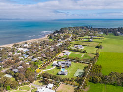
REAL ESTATE
Drone Photography and Video. Aerial drone photography of property with markups of property dimensions and measurements, showing proximity to schools, shopping centres and other nearby landmarks. Video can also be supplied in 4k to add to any ground based video edited and colour corrected.
Prices start from $253 inc GST for up to 8 images with markups.
CONSTRUCTION & ENGINEERING
Construction Progress Imagery. Aerial Drone photography of a construction site from start to finish. Shots are taken from the same angle throughout the build showing progress over time. Multiple visits are required. Video footage can be included as an extra.. Price on application
ASSET INSPECTION
Roof Inspections. Drones are a great way to inspect roof damage after a storm or hail event. The drone is flown close to the roof looking straight down and obliquely taking multiple images showing any details of damage for insurance claims..
Contact me for a price.
FILM & TELEVISION
Aerial Drone Videography Drone video for film and television production. With The Inspire 2 platform we can shoot in Apple Pro Res for Post Production requirements. With Interchangeable lenses we can shoot with short and long lenses in single and dual operator mode. We also have smaller drones that shoot in 4K for tighter spaces like flying from inside to outside a building.
MAPPING
Creating a 2D and 3D map of a property showing elevation, plant health and measurements of site area, stockpile measurements and building dimensions.
The flight is pre programmed and can be repeated at the same site every 2 or 3 months to show any changes. Very useful for Construction progress, and Planners.
Contact me for a quote for your project.

Orthomosaic

Plant Health Green is healthy Red is unhealthy

Elevation layer Blue is lowest Red is highest
For information and enquiries, please fill out the enquiry form or contact:
PH: +61 419 566 331